GIS facilitates land use type selection

GIS databases help experts make scientifically based decisions for the type of land use
Efficient land use involves assessing many environmental, geographic and economic factors. The rational location of farms and the method must necessarily take into account the slope of the earth’s surface, the type of soil and the number of shrinkage (in order to avoid water erosion of the soil, flooding of the surrounding areas and the rational use of water and treatment facilities during irrigation).
Currently, unfortunately, many land use areas on the island of Bali neglect or simply cannot follow the rules for the location of cultivated land, such as plowing across the slope, relative to rivers and other water bodies that are used as sources of drinking water, etc.
In order to overcome this, it is necessary to step up efforts in following the rules of soil and water conservation: it will reduce damage to the land and can provide benefits for farmers, including increased revenue.
Geographic Information Systems (GIS) is an information management tool that is strongly associated with mapping and analysis of all things and events that occur on earth. GIS is a computer-based system used to store, manipulate, and analyze geographic information, original information of the Earth’s surface is presented in the form of a map created manually, then with the presence of GIS, the information is processed by a computer, and the results in the form of digital maps. GIS does not only function as a “map maker”, but further than that, GIS is able to produce an information system that is applied, which can be used by planners or decision maker for the purposes of processing resources that exist in the region.
On the example of the district of Kintamani, Bangli, Bali Province, a study was conducted on land planning using field work and GIS. Also the study used soil type maps, physical maps, and land use maps. The main criteria of the land use method that was recommended by us in the process of planning the territory were: the level of the slope of the earth’s surface, the type of soil, the level of soil erosion hazard and the average daily rainfall. Classification for each factor is as follows:
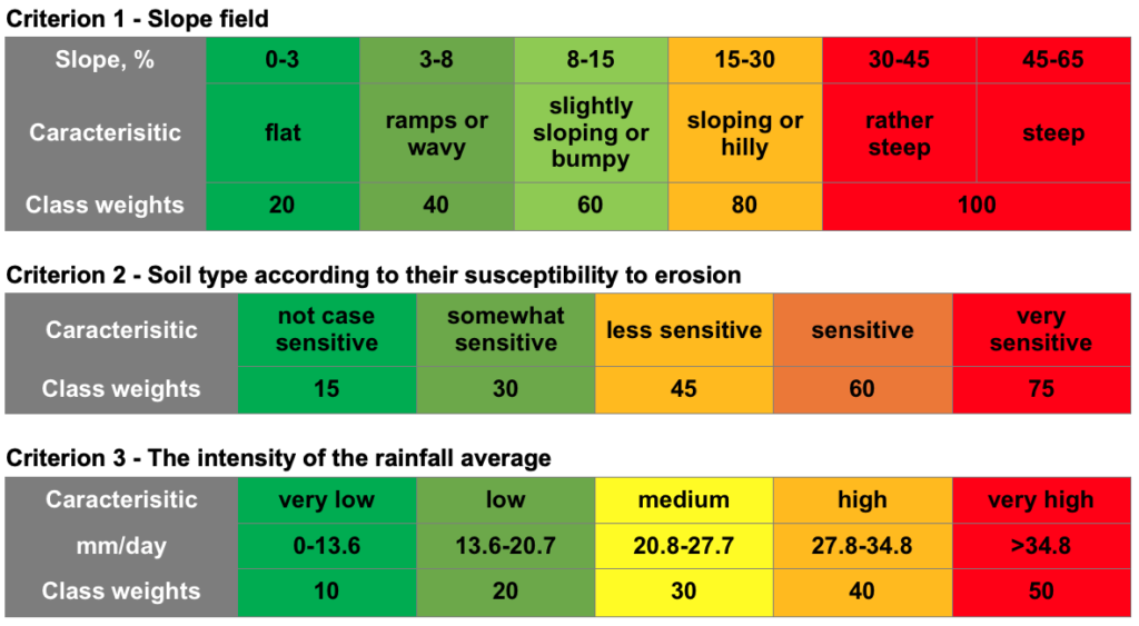
It is noteworthy that for each characteristic, its own range of weights was introduced, which makes it possible to evaluate the more or less significant role of each factor in assessing the type of suitability for use in a given territory. Weights are not a rigid characteristic, they can vary for different regions, and the criteria themselves can be changed or supplemented – it all depends on the geographical features of the study area and the goal set for the expert.
The sum of the weights reflects the suitability of the territory for a particular type of land use: for example, if the terrain is on a level surface, it is very sensitive to erosion and has an average amount of precipitation, the total score is 20 + 75 + 30 = 125, which is also unsatisfactory, like a steep slope even with a small amount of precipitation and protection from erosion (100 + 15 + 10 = 125).
GIS area class weight mapping example
As a result of the study, a GIS database was compiled, and an interactive map of the suitability of the territory for different types of land use. It was established that climatic factors had an extremely strong influence: since the level of precipitation varied mainly from 40 to 70 mm / day, the type of soil represented on more than 20 thousand ha of the study area turned out to be extremely sensitive to erosion, and the types of sheaves are presented in that to some extent evenly.
The resulting assessment allows to take measures to preserve and improve the quality of the land of the studied categories: sparing agriculture with periodic conservation of land with a score of up to 125, the use of land as a buffer zone with a score of 125 to 175 and land conservation with a score of more than 175.
Based on the results of the analysis it can be concluded that: 1) Land use in Kintamani mainly are buffer zones and protected areas; 2) In the buffer zone, it is recommended to doplanting intercropping (seasonal plant with annual crops or perennial plants with annual crops) and added organic matter or mulching; 3) For farm land, which is one of the most common land use conditions, it is necessary to use such sowing schemes that can be aimed at preserving the characteristics of cultivated land.
Full Text: