
Agricultural land planning
Agriculture is currently rapidly developing not only due to agricultural technologies, but also information technologies. The latter include geographic information systems (GIS).
In general, GIS allows you to accumulate, store, process, analyze and visualize all the information collected, which describes the agricultural land and natural conditions that determine the yield. GIS can be used to study individual farms, regions, and even countries (Hoffman, 2016).
The use of GIS technologies allows you to collect information about all the agricultural lands of the required territory over the years and track changes in soil fertility, yield values for different periods of time.
Nowadays GIS technologies allow to solve the most important tasks in agriculture for regions and countries on the basis of aerial and space images and field surveys data:
- determining the precise boundaries of the fields;
- identification of cultivated crops;
- calculation of vegetation indices characterizing the state of vegetation;
- yield forecasting, etc.
Like any other crop business, it aims to increase profits and reduce costs. GIS technologies can significantly help to do this with (URL: https://gisinfo.ru/item/65.htm):
- determination of optimal routes of movement of agricultural machinery from the base to the cultivated fields;
- implementation of planning of routes of movement of agricultural machinery at its following on the field on the smallest kilometer and the minimum expenses of fuel;
- selection of optimal timing of fertilizers, pesticides and irrigation;
- monitoring of soil and crops of various crops, etc.
Precision agriculture is based on the concept of heterogeneity of distribution of different properties of soils and crops within one field. It differs from traditional practices where irrigation and fertilization occur evenly within a single field. It is obvious that the traditional approach is not always justified in terms of raw material costs and the impact of measures on land improvement. There is another problem in the traditional approach, the same amount of application of substances (pesticides, fertilizers) for some areas may be excessive, and for others insufficient, which ultimately adversely affects the yield of crops https://www.gislounge.com/geospatial-technologies-in-precision-agriculture Precision agriculture provides an advanced agriculture management system that consists of GIS data analysis, remote sensing and global positioning techniques. The main idea is to control the yield on each plot of acreage using the set of tools mentioned above (Hoffman, 2016) (figure 1).
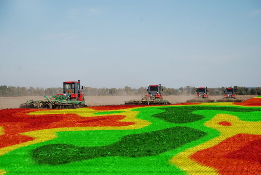
Fig. 1. The heterogeneity of the yield of the field (https://agroportal-ziz.ru/articles/v-orle-seyut-tochno)
The operation of such a system is based on the sampling of soil and crops at different points of the field. After collecting samples, agrochemical analysis is carried out. This allows us to determine the lack or excess of which substances is experiencing culture or soil (Fig. 2). The obtained data are interpolated over the entire territory of the analyzed territory, and the necessary amounts of fertilizer application are established. This approach is also characterized by the use of remote sensing data, space and aerial photographs in different spectral ranges. Special indices characterizing the state of vegetation or soil cover are often used to determine the content of K, N, P and other elements . These indices are calculated on the basis of field research data and remote sensing Data. It is noteworthy that the higher the spatial resolution of the images, the more detailed information about the state of crops can be extracted (Veronica Andreo, 2013). All collected and received data is moved to the GIS project. GIS projects can also contain information about the geographical factors affecting crops within the required fields: topography, groundwater depth, humidity and heat supply/ all data allow you to simulate the processes occurring with the acreage ( https://gisinfo.ru/item/65.htm).
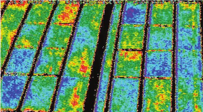
Fig. 2. Humidity in different areas of acreage (https://www.researchgate.net/publication/303231745_Remote_Sensing_and_GIS_Applications_in_Agriculture)
The data in the GIS project helps to calculate the amount of pesticides, fertilizers and other substances that need to be added to each site. Further, this information can be transmitted to on-Board computers of agricultural machinery equipped with special software. The transmitted information looks like a map, where it is drawn, where and how many substances to spray, while moving along a pre-laid route. Such measures lead to an increase in yields and a decrease in the amount of fertilizers used. The analysis allows to allocate the most fertile sites within the considerable territories intended for agriculture. In addition, the available data allow to make zoning of the territory and to choose the places most suitable for cultivation of certain types of crops, to calculate profit under various scenarios of use of territories (Hoffman, 2016).
Currently, GIS in agriculture can be both a tool for analysis and modeling, and a means of presenting source and derived information about agricultural land. GIS allow to make the account of fields, to carry out monitoring of agrochemical indicators of crops, to follow dynamics of these indicators in time. It is much better if field data on soil and crop conditions are collected several times a year. There is an accumulation of data and experience in management decision – making, which ultimately makes it possible to achieve success in predicting the size of crops, stable production of quality agricultural products, as well as assessing the effectiveness of reclamation measures.
References
1. Veronica Andrea. Remote Sensing and geographic Information Systems in Precision Farming / / MEW 9 Seminario. – 2013.
2. Hoffman V. V. Precision Agriculture and GIS / / ArcReview. – 2016. – No. 3 (78).
3. Geospatial Technologies in Precision Agriculture [Electronic resource] / / GIS LOUNGE. URL. https://www.gislounge.com/geospatial-technologies-in-precision-agriculture/ (accessed: 02.09.2019).
4. The use of GIS to ensure the technology of “precision agriculture” [Electronic resource] / / KB Panorama. URL: https://gisinfo.ru/item/65.htm (date accessed: 02.09.2019).